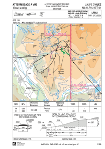


LFHU - L'alpe D'huez
Located in , France
ICAO - LFHU, IATA - AHZ
Data provided by AirmateGeneral information
Coordinates: N45°5'15" E6°5'1"
Elevation is 6103 feet MSL.
Magnetic variation is 2.14° East View others Airports in Rhône Alpes
Operational data
Special qualification required
Current time UTC:
Current local time:
Weather at : LFLB - Chambery Aix Les Bains ( 63 km )
METAR: LFLB 030530Z AUTO 35009KT 9999 FEW027 BKN034 OVC047 16/15 Q1017 TEMPO BKN006 BKN025
TAF: TAF LFLB 030200Z 0303/0403 VRB02KT 9999 BKN030 PROB40 TEMPO 0303/0308 BKN006 BKN025 TEMPO 0311/0318 FEW030TCU BKN033 PROB40 TEMPO 0312/0317 VRB12KT 4000 SHRA FEW028CB BKN030TCU PROB40 TEMPO 0400/0403 BKN006 PROB30 TEMPO 0400/0403 0500 FG VV///
Communications frequencies: [VIEW]
Runways:
| RWY identifier | QFU | Length (ft) | Width (ft) | Surface | LDA (ft) |
| 06 | 60° | 1470 | 98 | ASPH | 1470 |
| 24 | 240° | 1470 | 98 | ASPH |
Airport contact information
Address: France