logo
Search for airport 
image banner adimage banner adimage banner ad
image banner ad

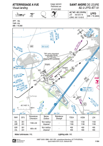
LFFD - Saint Andre De L'eure

Located in , France

ICAO - LFFD, IATA -

Data provided by Airmate  

General information

Coordinates: N48°53'51" E1°15'3"
Elevation is 491 feet MSL.
Magnetic variation is 0.68° East
View others Airports in Upper Normandy

Operational data

Special qualification required
Current time UTC:
Current local time:
Weather at : LFOE - Evreux Fauville ( 15 km )
METAR: LFOE 041200Z AUTO 28008KT 250V350 9999 SCT036 BKN043 BKN070 22/14 Q1013 NOSIG
TAF: TAF AMD LFOE 041020Z 0410/0509 23005KT 9999 SCT020 BECMG 0411/0413 28012KT BKN030 BECMG 0423/0501 BKN018 TEMPO 0504/0507 BKN012 PROB40 TEMPO 0508/0509 4000 -SHRA
View NOTAMs / SUP AIP / TFR affecting this airport [VIEW]
Communications frequencies: [VIEW]

Runways:

RWY identifierQFULength (ft)Width (ft)SurfaceLDA (ft)
05L52°3609164GRASS3609
23R232°3609164GRASS3609
05R52°1312131GRASS1312
23L232°1312131GRASS1312

Airport contact information

Address: France

Fuel provider

TotalEnergies

TotalEnergies
+33 232375280

Other aviation service providers

Aviation club (not for profit)

Aéroclub d'Evreux les Authieux

Aéroclub d'Evreux les Authieux

Club Aéronautique de St André

Club Aéronautique de St André

Aviation medical examiner

Dr Dupuis Claude

Dr Dupuis Claude
+33 232375406

Satellite view of LFFD