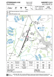


LFES - Guiscriff Scaer
Located in , France
ICAO - LFES, IATA -
Data provided by AirmateGeneral information
Coordinates: N48°3'13" W3°39'51"
Elevation is 574 feet MSL.
Magnetic variation is -0.83° East View others Airports in Brittany
Operational data
Special qualification required
Current time UTC:
Current local time:
Communications frequencies: [VIEW]
Runways:
| RWY identifier | QFU | Length (ft) | Width (ft) | Surface | LDA (ft) |
| 02 | 23° | 4921 | 98 | ASPH | 4921 |
| 20 | 203° | 4921 | 98 | ASPH | 4921 |
| 02R | 23° | 984 | 66 | GRASS | |
| 20L | 203° | 984 | 66 | GRASS |
Airport contact information
Address: France

