logo
Search for airport 
image banner adimage banner adimage banner ad
image banner ad

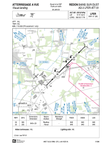
LFER - Redon Bains Sur Oust

Located in Redon, France

ICAO - LFER, IATA - XRN

Data provided by Airmate  

General information

Coordinates: N47°41'55" W2°2'17"
Elevation is 225 feet MSL.
Magnetic variation is -0.26° East
Rated:
View ratings:
[VIEW]
View others Airports in Brittany

Operational data

Special qualification required
Current time UTC:
Current local time:
Weather at : LFRZ - Saint Nazaire Montoir ( 44 km )
METAR: LFRZ 181300Z AUTO 17004KT 130V290 9999 FEW027 SCT036 22/17 Q1011 TEMPO 4000 -SHRA BKN025CB
TAF: TAF LFRZ 181100Z 1812/1912 VRB04KT 9999 BKN020 TEMPO 1814/1821 4000 -SHRA BKN025CB PROB30 TEMPO 1815/1818 2500 TSRA BKN012CB TEMPO 1902/1906 4500 -RA PROB40 TEMPO 1903/1912 2500 RA BKN014 SCT020CB
View NOTAMs / SUP AIP / TFR affecting this airport [VIEW]
Communications frequencies: [VIEW]

Runways:

RWY identifierQFULength (ft)Width (ft)SurfaceLDA (ft)
0444°275666ASPH2756
22224°275666ASPH2756

Airport contact information

Address: Redon France

Other aviation service providers

Aviation club (not for profit)

Aéroclub Redonnais

Aéroclub Redonnais

Satellite view of LFER