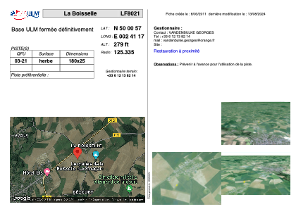


LF8021 - La Boisselle
Located in Ovillers-La-Boisselle, France
ICAO - , IATA -
Data provided by AirmateGeneral information
Coordinates: N50°0'57" E2°41'17"
Elevation is 279 feet MSL.
View others Airports in Picardie
Operational data
Special qualification required
Current time UTC:
Current local time:
Weather at : LFAQ - Albert Bray ( 5 km )
METAR: LFAQ 140130Z AUTO 18009KT 9999 OVC036 12/10 Q1008
TAF: TAF LFAQ 131400Z 1315/1324 23010KT 9999 FEW040 BKN140 PROB30 TEMPO 1322/1324 4500 -RA
Communications frequencies: [VIEW]
Runways:
| RWY identifier | QFU | Length (ft) | Width (ft) | Surface | LDA (ft) |
| 03 | 0° | 590 | 82 | GRASS | |
| 21 | 0° | 590 | 82 | GRASS |
Airport contact information
Address: Ovillers-La-Boisselle France