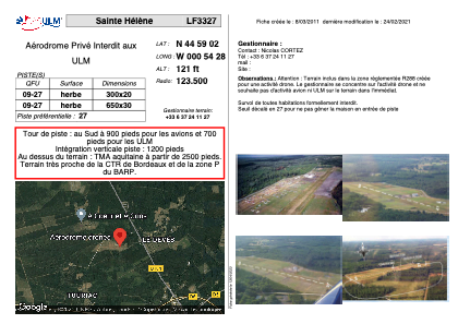


LF3327 - Sainte Hélène
Located in Sainte-Hélène, France
ICAO - , IATA -
Data provided by AirmateGeneral information
Coordinates: N44°59'2" W0°54'28"
Elevation is 121 feet MSL.
View others Airports in Aquitaine
Operational data
Special qualification required
Current time UTC:
Current local time:
Weather at : LFBD - Bordeaux Merignac ( 23 km )
METAR: LFBD 011930Z AUTO 02005KT 310V060 CAVOK 18/12 Q1021 NOSIG
TAF: TAF LFBD 011700Z 0118/0224 02010KT CAVOK TX23/0215Z TN11/0205Z BECMG 0208/0210 BKN020 PROB30 TEMPO 0212/0215 4500 -SHRA BKN020TCU BECMG 0220/0222 CAVOK
Communications frequencies: [VIEW]
Runways:
| RWY identifier | QFU | Length (ft) | Width (ft) | Surface | LDA (ft) |
| 09 | 0° | 984 | 65 | GRASS | |
| 27 | 0° | 984 | 65 | GRASS |
Airport contact information
Address: Sainte-Hélène France