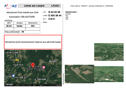


LF2431 - Liorac sur Louyre
Located in Liorac-sur-Louyre, France
ICAO - , IATA -
Data provided by AirmateGeneral information
Coordinates: N44°55'8" E0°38'44"
Elevation is 518 feet MSL.
View others Airports in Aquitaine
Operational data
Special qualification required
Current time UTC:
Current local time:
Weather at : LFBE - Bergerac Dordogne Perigord ( 14 km )
METAR: LFBE 181130Z AUTO 14006KT 090V160 9999 SCT026/// SCT150/// BKN210/// ///TCU 24/19 Q1012 BECMG BKN025
TAF: TAF LFBE 181100Z 1812/1912 14005KT CAVOK TEMPO 1816/1904 4000 SHRA BKN050CB PROB40 TEMPO 1816/1818 VRB30G50KT PROB40 TEMPO 1816/1823 2000 TSRAGR BKN008 PROB40 TEMPO 1823/1901 BKN005 PROB30 TEMPO 1901/1904 VRB10G30KT 2000 TSRA BKN005 BKN020CB TEMPO 1904/1906 2000 BR BECMG 1906/1908 27010KT SCT010
Communications frequencies: [VIEW]
Runways:
| RWY identifier | QFU | Length (ft) | Width (ft) | Surface | LDA (ft) |
| 06 | 0° | 1476 | 0 | GRASS | |
| 24 | 0° | 1476 | 0 | GRASS |
Airport contact information
Address: Liorac-sur-Louyre France