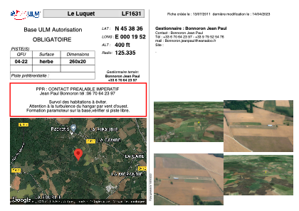


LF1631 - Le Luquet
Located in Chazelles, France
ICAO - , IATA -
Data provided by AirmateGeneral information
Coordinates: N45°38'36" E0°19'52"
Elevation is 400 feet MSL.
View others Airports in Poitou-Charentes
Operational data
Special qualification required
Current time UTC:
Current local time:
Weather at : LFBU - Angouleme Brie Champniers ( 13 km )
METAR: LFBU 161400Z AUTO 21010KT 180V240 6000 2800 BKN017/// BKN024/// OVC052/// ///TCU 20/16 Q1011 TEMPO 23015G25KT 4000 SHRA BKN008 BKN020TCU
TAF: TAF LFBU 161100Z 1612/1712 20010KT 9999 BKN020 TEMPO 1612/1710 4000 SHRA BKN008 BKN020TCU PROB40 TEMPO 1612/1618 23015G25KT BECMG 1710/1712 12005KT
Communications frequencies: [VIEW]
Runways:
| RWY identifier | QFU | Length (ft) | Width (ft) | Surface | LDA (ft) |
| 04 | 0° | 853 | 65 | GRASS | |
| 22 | 0° | 853 | 65 | GRASS |
Airport contact information
Address: Chazelles France