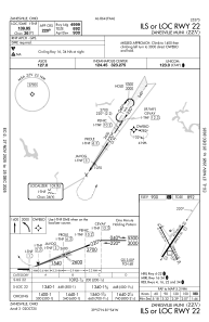
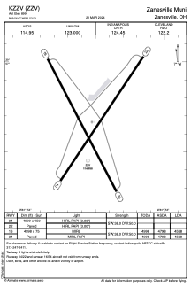


KZZV - Zanesville Muni
Located in Zanesville, United States
ICAO - ZZV, IATA - ZZV
Data provided by AirmateGeneral information
Coordinates: N39°56'40" W81°53'32"
Elevation is 899 feet MSL.
Magnetic variation is -06° East View others Airports in Ohio
Operational data
Special qualification required
Current time UTC:
Current local time:
Communications frequencies: [VIEW]
Runways:
| RWY identifier | QFU | Length (ft) | Width (ft) | Surface | LDA (ft) |
| 04 | 34° | 4999 | 150 | ASPH | |
| 22 | 214° | 4999 | 150 | ASPH | |
| 16 | 152° | 4998 | 75 | ASPH | 4598 |
| 34 | 332° | 4998 | 75 | ASPH | 4598 |
Airport contact information
Address: Zanesville United States