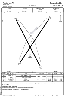


KZZV - Zanesville Muni
Located in Zanesville, United States
ICAO - ZZV, IATA - ZZV
Data provided by AirmateGeneral information
Coordinates: N39°56'40" W81°53'32"
Elevation is 899 feet MSL.
Magnetic variation is -06° East View others Airports in Ohio
Operational data
Special qualification required
Current time UTC:
Current local time:
Weather
METAR: KZZV 232153Z AUTO 21006KT 10SM CLR 25/16 A2991 RMK AO2 SLP123 T02500161
TAF: KZZV 231720Z 2318/2418 20005KT P6SM SCT040 SCT050 FM240500 00000KT P6SM BKN090 FM240700 00000KT 3SM BR BKN050 FM241000 00000KT 1SM BR BKN015 FM241300 00000KT P6SM SCT015
Communications frequencies: [VIEW]
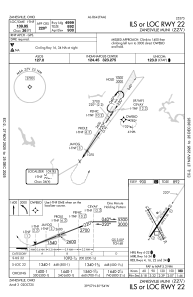
Runways:
| RWY identifier | QFU | Length (ft) | Width (ft) | Surface | LDA (ft) |
| 04 | 34° | 4999 | 150 | ASPH | |
| 22 | 214° | 4999 | 150 | ASPH | |
| 16 | 152° | 4998 | 75 | ASPH | 4598 |
| 34 | 332° | 4998 | 75 | ASPH | 4598 |
Airport contact information
Address: Zanesville United States