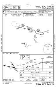
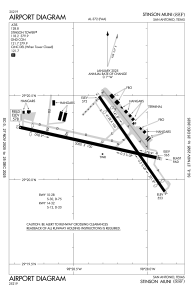


KSSF - Stinson Muni
Located in San Antonio, United States
ICAO - SSF, IATA -
Data provided by AirmateGeneral information
Coordinates: N29°20'13" W98°28'16"
Elevation is 577 feet MSL.
Magnetic variation is 08° East View others Airports in Texas
Operational data
Special qualification required
Current time UTC:
Current local time:
Communications frequencies: [VIEW]
Runways:
| RWY identifier | QFU | Length (ft) | Width (ft) | Surface | LDA (ft) |
| 09 | 103° | 5000 | 100 | ASPH | 4550 |
| 27 | 283° | 5000 | 100 | ASPH | 4677 |
| 14 | 145° | 4128 | 100 | ASPH | 3297 |
| 32 | 325° | 4128 | 100 | ASPH | 3530 |
Airport contact information
Address: San Antonio United States
