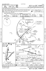
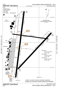


KSJT - San Angelo Rgnl/Mathis Fld
Located in San Angelo, United States
ICAO - SJT, IATA - SJT
Data provided by AirmateGeneral information
Coordinates: N31°21'28" W100°29'47"
Elevation is 1918 feet MSL.
Magnetic variation is 05° East View others Airports in Texas
Operational data
Special qualification required
Current time UTC:
Current local time:
Communications frequencies: [VIEW]
Runways:
| RWY identifier | QFU | Length (ft) | Width (ft) | Surface | LDA (ft) |
| 03 | 43° | 5940 | 150 | ASPH | 5940 |
| 21 | 223° | 5940 | 150 | ASPH | 5940 |
| 09 | 97° | 4406 | 75 | ASPH | 4406 |
| 27 | 277° | 4406 | 75 | ASPH | 4406 |
| 18 | 187° | 8054 | 150 | ASPH | 7152 |
| 36 | 7° | 8054 | 150 | ASPH | 7152 |
Airport contact information
Address: San Angelo United States
Other aviation service providers
Flight schools

San Angelo Flying Enterprise, Llc
San Angelo Flying Enterprise, Llc
sanangeloflying@gmail.com+1(325)895-0638