


KPDT - Eastern Oregon Rgnl At Pendleton
Located in Pendleton, United States
ICAO - PDT, IATA - PDT
Data provided by AirmateGeneral information
Coordinates: N45°41'42" W118°50'36"
Elevation is 1494 feet MSL.
Magnetic variation is 16° East View others Airports in Oregon
Operational data
Special qualification required
Current time UTC:
Current local time:
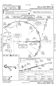
Communications frequencies: [VIEW]
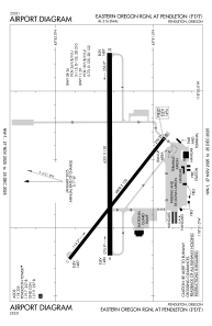
Runways:
| RWY identifier | QFU | Length (ft) | Width (ft) | Surface | LDA (ft) |
| 08 | 90° | 6301 | 150 | ASPH | 6301 |
| 26 | 270° | 6301 | 150 | ASPH | 6301 |
| 11 | 128° | 4808 | 100 | ASPH | 4808 |
| 29 | 308° | 4808 | 100 | ASPH | 4808 |
Airport contact information
Address: Pendleton United States
