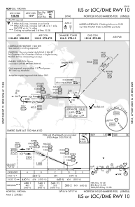
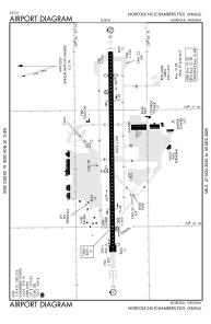


KNGU - Norfolk Ns (Chambers Fld)
Located in Norfolk, United States
ICAO - NGU, IATA -
Data provided by AirmateGeneral information
Coordinates: N36°56'15" W76°17'21"
Elevation is 14 feet MSL.
Magnetic variation is -10° East View others Airports in Virginia
Operational data
Special qualification required
Current time UTC:
Current local time:
Communications frequencies: [VIEW]
Runways:
| RWY identifier | QFU | Length (ft) | Width (ft) | Surface | LDA (ft) |
| 10 | 90° | 8370 | 200 | ASPH | 8071 |
| 28 | 270° | 8370 | 200 | ASPH | 7375 |
Airport contact information
Address: Norfolk United States