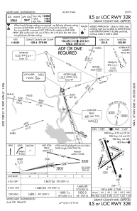
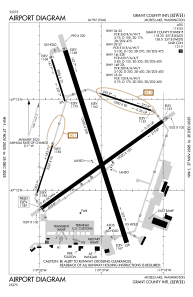


KMWH - Grant County Intl
Located in Moses Lake, United States
ICAO - MWH, IATA - MWH
Data provided by AirmateGeneral information
Coordinates: N47°12'31" W119°19'9"
Elevation is 1188 feet MSL.
Magnetic variation is 18° East View others Airports in Washington
Operational data
Special qualification required
Current time UTC:
Current local time:
Communications frequencies: [VIEW]
Runways:
| RWY identifier | QFU | Length (ft) | Width (ft) | Surface | LDA (ft) |
| 04 | 54° | 10000 | 100 | CONC | 10000 |
| 22 | 234° | 10000 | 100 | CONC | 10000 |
| 09 | 108° | 3500 | 90 | CONC | 3500 |
| 27 | 288° | 3500 | 90 | CONC | 3500 |
| 14L | 162° | 13503 | 200 | CONC | 13503 |
| 32R | 342° | 13503 | 200 | CONC | 13492 |
| 14R | 162° | 2936 | 75 | CONC | 2936 |
| 32L | 342° | 2936 | 75 | CONC | 2936 |
| 18 | 198° | 3327 | 75 | ASPH | |
| 36 | 18° | 3327 | 75 | ASPH | |
| H1 | 0° | 0 | 0 | UNK | |
| H2 | 0° | 0 | 0 | UNK |
Airport contact information
Address: Moses Lake United States
