


KMOT - Minot Intl
Located in Minot, United States
ICAO - MOT, IATA - MOT
Data provided by AirmateGeneral information
Coordinates: N48°15'28" W101°16'41"
Elevation is 1715 feet MSL.
Magnetic variation is 06° East View others Airports in North Dakota
Operational data
Special qualification required
Current time UTC:
Current local time:
Communications frequencies: [VIEW]
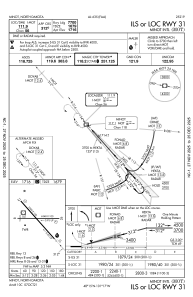
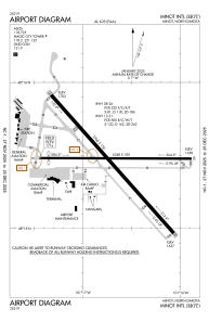
Runways:
| RWY identifier | QFU | Length (ft) | Width (ft) | Surface | LDA (ft) |
| 08 | 90° | 6348 | 100 | ASPH | 5958 |
| 26 | 270° | 6348 | 100 | ASPH | 6348 |
| 13 | 138° | 7700 | 150 | CONC | 7700 |
| 31 | 318° | 7700 | 150 | CONC | 7700 |
Airport contact information
Address: Minot United States
Other aviation service providers
Flight schools

Minot Aero Center & Pietsch Aircraft
Minot Aero Center & Pietsch Aircraft
customerservice@minotaerocenter.com+1(701)857-4738