


KMIA - Miami Intl
Located in Miami, United States
ICAO - MIA, IATA - MIA
Data provided by AirmateGeneral information
Coordinates: N25°47'43" W80°17'24"
Elevation is 9 feet MSL.
Magnetic variation is -05° East View others Airports in Florida
Operational data
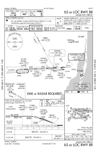
Special qualification required
Current time UTC:
Current local time:
Weather
METAR: KMIA 230753Z 00000KT 10SM FEW032 26/21 A2997 RMK AO2 SLP150 T02560206 $
TAF: KMIA 230520Z 2306/2412 VRB04KT P6SM FEW030 FM231500 07007KT P6SM FEW030 SCT050 FM231800 10010KT P6SM SCT030 SCT050 FM240300 VRB03KT P6SM FEW060
Communications frequencies: [VIEW]
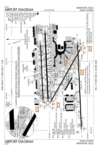
Runways:
| RWY identifier | QFU | Length (ft) | Width (ft) | Surface | LDA (ft) |
| 08L | 87° | 8600 | 150 | ASPH | 8600 |
| 26R | 267° | 8600 | 150 | ASPH | 8600 |
| 08R | 87° | 10506 | 200 | ASPH | 10506 |
| 26L | 267° | 10506 | 200 | ASPH | 10220 |
| 09 | 87° | 13016 | 150 | ASPH | 11397 |
| 27 | 267° | 13016 | 150 | ASPH | 12755 |
| 12 | 119° | 9360 | 150 | ASPH | 8579 |
| 30 | 299° | 9360 | 150 | ASPH | 7913 |
Airport contact information
Address: Miami United States
