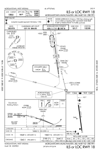


KMGW - Morgantown Muni/Walter L Bill Hart Fld
Located in Morgantown, United States
ICAO - MGW, IATA - MGW
Data provided by AirmateGeneral information
Coordinates: N39°38'37" W79°55'3"
Elevation is 1243 feet MSL.
Magnetic variation is -09° East View others Airports in West Virginia
Operational data
Special qualification required
Current time UTC:
Current local time:
Communications frequencies: [VIEW]
Runways:
| RWY identifier | QFU | Length (ft) | Width (ft) | Surface | LDA (ft) |
| 18 | 172° | 5199 | 150 | ASPH | 5199 |
| 36 | 352° | 5199 | 150 | ASPH | 5199 |
Airport contact information
Address: Morgantown United States
