


KMCW - Mason City Muni
Located in Mason City, United States
ICAO - MCW, IATA - MCW
Data provided by AirmateGeneral information
Coordinates: N43°9'28" W93°19'53"
Elevation is 1213 feet MSL.
Magnetic variation is 00° East View others Airports in Iowa
Operational data
Special qualification required
Current time UTC:
Current local time:
Communications frequencies: [VIEW]
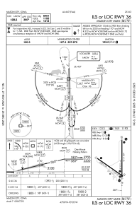
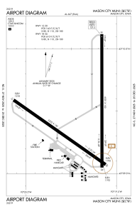
Runways:
| RWY identifier | QFU | Length (ft) | Width (ft) | Surface | LDA (ft) |
| 12 | 125° | 5502 | 150 | ASPH | 5501 |
| 30 | 305° | 5502 | 150 | ASPH | 5501 |
| 18 | 180° | 6501 | 150 | ASPH | 6501 |
| 36 | 360° | 6501 | 150 | ASPH | 6401 |
Airport contact information
Address: Mason City United States
