


KLTS - Altus Afb
Located in Altus, United States
ICAO - LTS, IATA - LTS
Data provided by AirmateGeneral information
Coordinates: N34°40'5" W99°16'4"
Elevation is 1382 feet MSL.
Magnetic variation is 05° East View others Airports in Oklahoma
Operational data
Special qualification required
Current time UTC:
Current local time:
Communications frequencies: [VIEW]
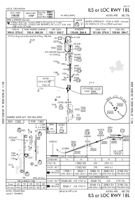
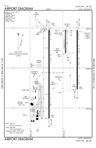
Runways:
| RWY identifier | QFU | Length (ft) | Width (ft) | Surface | LDA (ft) |
| 176 | 180° | 3500 | 90 | CONC | |
| 356 | 360° | 3500 | 90 | CONC | |
| 18L | 180° | 9001 | 150 | CONC | |
| 36R | 360° | 9001 | 150 | CONC | |
| 18R | 180° | 13440 | 150 | CONC | |
| 36L | 360° | 13440 | 150 | CONC |
Airport contact information
Address: Altus United States