


KLQR - Larned-Pawnee County
Located in Larned, United States
ICAO - LQR, IATA -
Data provided by AirmateGeneral information
Coordinates: N38°12'31" W99°5'9"
Elevation is 2012 feet MSL.
Magnetic variation is 08° East View others Airports in Kansas
Operational data
Special qualification required
Current time UTC:
Current local time:
Communications frequencies: [VIEW]
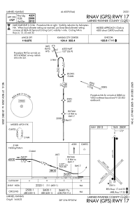
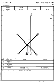
Runways:
| RWY identifier | QFU | Length (ft) | Width (ft) | Surface | LDA (ft) |
| 04 | 45° | 2860 | 170 | GRASS | |
| 22 | 225° | 2860 | 170 | GRASS | |
| 12 | 135° | 2830 | 180 | GRASS | |
| 30 | 315° | 2830 | 180 | GRASS | |
| 17 | 180° | 4201 | 75 | CONC | |
| 35 | 360° | 4201 | 75 | CONC |
Airport contact information
Address: Larned United States