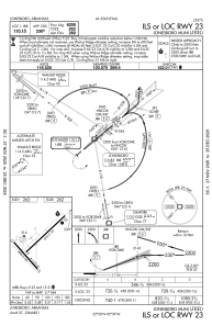
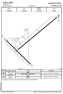


KJBR - Jonesboro Muni
Located in Jonesboro, United States
ICAO - JBR, IATA - JBR
Data provided by AirmateGeneral information
Coordinates: N35°49'54" W90°38'47"
Elevation is 262 feet MSL.
Magnetic variation is -00° East View others Airports in Arkansas
Operational data
Special qualification required
Current time UTC:
Current local time:
Communications frequencies: [VIEW]
Runways:
| RWY identifier | QFU | Length (ft) | Width (ft) | Surface | LDA (ft) |
| 05 | 50° | 6200 | 150 | ASPH | |
| 23 | 230° | 6200 | 150 | ASPH | |
| 13 | 135° | 4099 | 150 | ASPH | |
| 31 | 315° | 4099 | 150 | ASPH |
Airport contact information
Address: Jonesboro United States
