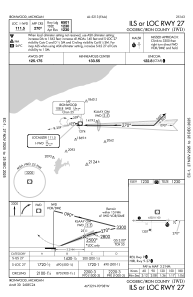
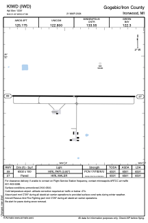


KIWD - Gogebic/Iron County
Located in Ironwood, United States
ICAO - IWD, IATA - IWD
Data provided by AirmateGeneral information
Coordinates: N46°31'39" W90°7'53"
Elevation is 1230 feet MSL.
Magnetic variation is 00° East View others Airports in Michigan
Operational data
Special qualification required
Current time UTC:
Current local time:
Communications frequencies: [VIEW]
Runways:
| RWY identifier | QFU | Length (ft) | Width (ft) | Surface | LDA (ft) |
| 09 | 90° | 6502 | 100 | ASPH | 6501 |
| 27 | 270° | 6502 | 100 | ASPH | 6501 |
Airport contact information
Address: Ironwood United States