


KHUF - Terre Haute Rgnl
Located in Terre Haute, United States
ICAO - HUF, IATA - HUF
Data provided by AirmateGeneral information
Coordinates: N39°27'2" W87°18'25"
Elevation is 589 feet MSL.
Magnetic variation is -02° East View others Airports in Indiana
Operational data
Special qualification required
Current time UTC:
Current local time:
Weather
METAR: KHUF 210020Z 04005KT 10SM VCTS FEW055 SCT120 23/22 A2984 RMK AO2 LTG DSNT E AND S RAE15 TSB2357E14 P0002 T02280217
TAF: KHUF 202322Z 2100/2124 20010KT P6SM SCT030 BKN060 TEMPO 2100/2101 5SM -TSRA BR OVC035CB FM210100 VRB04KT P6SM SCT060 BKN200 FM210800 00000KT 4SM BR BCFG FEW010 SCT030 FM211400 17005KT P6SM SCT250
Communications frequencies: [VIEW]
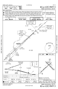
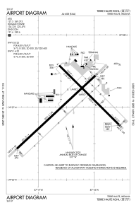
Runways:
| RWY identifier | QFU | Length (ft) | Width (ft) | Surface | LDA (ft) |
| 05 | 47° | 9021 | 150 | ASPH | 9020 |
| 23 | 227° | 9021 | 150 | ASPH | 9020 |
| 14 | 135° | 7200 | 150 | OTHER | 7200 |
| 32 | 315° | 7200 | 150 | OTHER | 7200 |
Airport contact information
Address: Terre Haute United States
