


KHRO - Boone County
Located in Harrison, United States
ICAO - HRO, IATA - HRO
Data provided by AirmateGeneral information
Coordinates: N36°15'41" W93°9'17"
Elevation is 1364 feet MSL.
Magnetic variation is 04° East View others Airports in Arkansas
Operational data
Special qualification required
Current time UTC:
Current local time:
Communications frequencies: [VIEW]
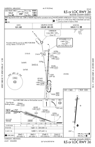
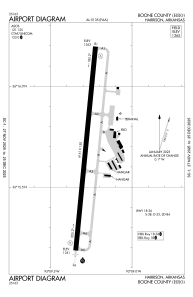
Runways:
| RWY identifier | QFU | Length (ft) | Width (ft) | Surface | LDA (ft) |
| 18 | 186° | 6161 | 150 | ASPH | |
| 36 | 6° | 6161 | 150 | ASPH |
Airport contact information
Address: Harrison United States