


KGTR - Golden Triangle Rgnl
Located in Columbus/W Point/Starkville, United States
ICAO - GTR, IATA - GTR
Data provided by AirmateGeneral information
Coordinates: N33°26'54" W88°35'29"
Elevation is 264 feet MSL.
Magnetic variation is -02° East View others Airports in Mississippi
Operational data
Special qualification required
Current time UTC:
Current local time:
Communications frequencies: [VIEW]
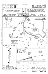
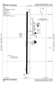
Runways:
| RWY identifier | QFU | Length (ft) | Width (ft) | Surface | LDA (ft) |
| 18 | 180° | 8003 | 150 | ASPH | |
| 36 | 0° | 8003 | 150 | ASPH |
Airport contact information
Address: Columbus/W Point/Starkville United States
