


KGTF - Great Falls Intl
Located in Great Falls, United States
ICAO - GTF, IATA - GTF
Data provided by AirmateGeneral information
Coordinates: N47°28'56" W111°22'13"
Elevation is 3680 feet MSL.
Magnetic variation is 13° East View others Airports in Montana
Operational data
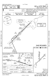
Special qualification required
Current time UTC:
Current local time:
Weather
METAR: KGTF 282253Z 17011KT 10SM CLR 28/05 A2988 RMK AO2 SLP097 T02780050
TAF: KGTF 282325Z 2900/2924 18015G27KT P6SM VCSH BKN110 FM290100 26008KT P6SM VCTS BKN100CB TEMPO 2902/2904 VRB12G30KT 4SM -TSRA OVC030CB FM290400 19008KT P6SM BKN110 PROB30 2909/2912 4SM -SHRA BR OVC025 FM291400 26011KT P6SM BKN035 PROB30 2914/2917 4SM -SHRA BR OVC025
Communications frequencies: [VIEW]
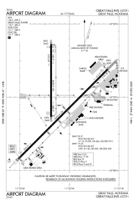
Runways:
| RWY identifier | QFU | Length (ft) | Width (ft) | Surface | LDA (ft) |
| 03 | 45° | 10502 | 150 | ASPH | 10502 |
| 21 | 225° | 10502 | 150 | ASPH | 10502 |
| 17 | 180° | 6030 | 150 | ASPH | 5800 |
| 35 | 360° | 6030 | 150 | ASPH | 5400 |
Airport contact information
Address: Great Falls United States