


KGGW - Wokal Fld/Glasgow-Valley County
Located in Glasgow, United States
ICAO - GGW, IATA - GGW
Data provided by AirmateGeneral information
Coordinates: N48°12'45" W106°36'53"
Elevation is 2295 feet MSL.
Magnetic variation is 11° East View others Airports in Montana
Operational data
Special qualification required
Current time UTC:
Current local time:
Communications frequencies: [VIEW]
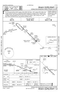
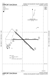
Runways:
| RWY identifier | QFU | Length (ft) | Width (ft) | Surface | LDA (ft) |
| 08 | 90° | 5000 | 75 | ASPH | 5000 |
| 26 | 270° | 5000 | 75 | ASPH | 5000 |
| 12 | 134° | 5002 | 100 | ASPH | 5001 |
| 30 | 314° | 5002 | 100 | ASPH | 5001 |
Airport contact information
Address: Glasgow United States