


KEWR - Newark Liberty Intl
Located in Newark, United States
ICAO - EWR, IATA - EWR
Data provided by AirmateGeneral information
Coordinates: N40°41'33" W74°10'7"
Elevation is 17 feet MSL.
Magnetic variation is -13° East View others Airports in New Jersey
Operational data
Special qualification required
Current time UTC:
Current local time:
Weather
TAF: KEWR 231131Z 2312/2418 21007KT P6SM -SHRA OVC040 TEMPO 2313/2314 25009G20KT 3SM TSRA BKN035CB BKN050 FM231400 29008KT P6SM -SHRA BKN040 TEMPO 2314/2316 27008G20KT 3SM TSRA BKN035CB BKN050 FM231900 24008KT P6SM VCSH BKN040 FM240100 25008KT P6SM BKN040 FM240600 29008KT P6SM SCT040 FM240900 36005KT P6SM SCT040 FM241400 25007KT P6SM SCT040
Communications frequencies: [VIEW]
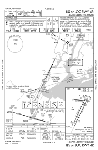
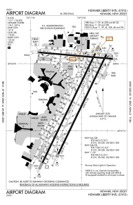
Runways:
| RWY identifier | QFU | Length (ft) | Width (ft) | Surface | LDA (ft) |
| 04L | 26° | 11000 | 150 | OTHER | 8460 |
| 22R | 206° | 11000 | 150 | OTHER | 9560 |
| 04R | 26° | 10000 | 150 | ASPH | 8810 |
| 22L | 206° | 10000 | 150 | ASPH | 8207 |
| 11 | 95° | 6726 | 150 | ASPH | 6726 |
| 29 | 275° | 6726 | 150 | ASPH | 6502 |
| H1 | 0° | 0 | 0 | UNK |
Airport contact information
Address: Newark United States