


KENW - Kenosha Rgnl
Located in Kenosha, United States
ICAO - ENW, IATA - ENW
Data provided by AirmateGeneral information
Coordinates: N42°35'46" W87°55'38"
Elevation is 742 feet MSL.
Magnetic variation is -02° East View others Airports in Wisconsin
Operational data
Special qualification required
Current time UTC:
Current local time:
Weather
METAR: KENW 291053Z AUTO 35007KT 10SM CLR 13/11 A3011 RMK AO2 SLP197 T01330111 $
TAF: KENW 291120Z 2912/3012 35008KT P6SM SCT110 FM291800 03011KT P6SM SCT070 FM300100 VRB05KT P6SM SKC
Communications frequencies: [VIEW]
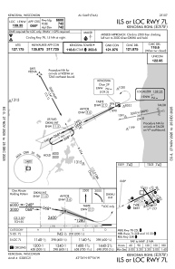
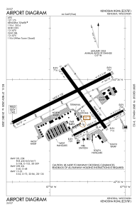
Runways:
| RWY identifier | QFU | Length (ft) | Width (ft) | Surface | LDA (ft) |
| 07L | 64° | 6600 | 100 | CONC | |
| 25R | 244° | 6600 | 100 | CONC | |
| 07R | 64° | 3302 | 75 | OTHER | |
| 25L | 244° | 3302 | 75 | OTHER | |
| 15 | 144° | 4440 | 100 | CONC | |
| 33 | 324° | 4440 | 100 | CONC |
Airport contact information
Address: Kenosha United States
