


KEKO - Elko Rgnl
Located in Elko, United States
ICAO - EKO, IATA - EKO
Data provided by AirmateGeneral information
Coordinates: N40°49'30" W115°47'29"
Elevation is 5139 feet MSL.
Magnetic variation is 12° East View others Airports in Nevada
Operational data
Special qualification required
Current time UTC:
Current local time:
Communications frequencies: [VIEW]
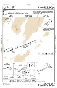
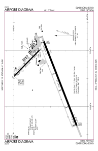
Runways:
| RWY identifier | QFU | Length (ft) | Width (ft) | Surface | LDA (ft) |
| 06 | 69° | 7454 | 150 | ASPH | 7217 |
| 24 | 249° | 7454 | 150 | ASPH | 6418 |
| 12 | 134° | 3015 | 60 | ASPH | 2109 |
| 30 | 314° | 3015 | 60 | ASPH | 2872 |
Airport contact information
Address: Elko United States
Other aviation service providers
Flight schools

Mountain West Aviation / El Aero Services
Mountain West Aviation / El Aero Services
elaero1@frontiernet.net7757387123