


KEDW - Edwards Afb
Located in Edwards, United States
ICAO - EDW, IATA -
Data provided by AirmateGeneral information
Coordinates: N34°54'29" W117°53'8"
Elevation is 2311 feet MSL.
Magnetic variation is 12° East View others Airports in California
Operational data
Special qualification required
Current time UTC:
Current local time:
Communications frequencies: [VIEW]
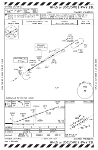
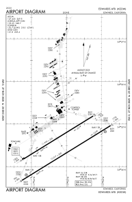
Runways:
| RWY identifier | QFU | Length (ft) | Width (ft) | Surface | LDA (ft) |
| 05L | 0° | 12000 | 200 | ASPH | |
| 23R | 0° | 12000 | 200 | ASPH | |
| 05R | 58° | 15024 | 300 | CONC | |
| 23L | 238° | 15024 | 300 | CONC | |
| 07 | 0° | 8000 | 50 | CONC | |
| 25 | 0° | 8000 | 50 | CONC |
Airport contact information
Address: Edwards United States
