


KDVL - Devils Lake Rgnl
Located in Devils Lake, United States
ICAO - DVL, IATA - DVL
Data provided by AirmateGeneral information
Coordinates: N48°6'60" W98°54'36"
Elevation is 1469 feet MSL.
Magnetic variation is 07° East View others Airports in North Dakota
Operational data
Special qualification required
Current time UTC:
Current local time:
Communications frequencies: [VIEW]
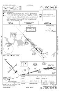
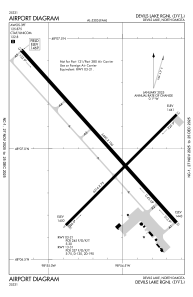
Runways:
| RWY identifier | QFU | Length (ft) | Width (ft) | Surface | LDA (ft) |
| 03 | 45° | 4314 | 75 | ASPH | 4314 |
| 21 | 225° | 4314 | 75 | ASPH | 4314 |
| 13 | 138° | 6400 | 100 | ASPH | 6401 |
| 31 | 318° | 6400 | 100 | ASPH | 6401 |
Airport contact information
Address: Devils Lake United States