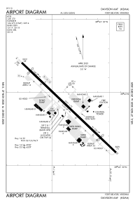


KDAA - Davison Aaf
Located in Fort Belvoir, United States
ICAO - DAA, IATA - DAA
Data provided by AirmateGeneral information
Coordinates: N38°42'54" W77°10'51"
Elevation is 73 feet MSL.
Magnetic variation is -09° East View others Airports in Virginia
Operational data
Special qualification required
Current time UTC:
Current local time:
Weather
METAR: KDAA 031155Z AUTO 25003KT 10SM SCT080 23/18 A2996 RMK AO2 RAB1057E07 SLP148 P0000 60000 T02270182 10233 20194 51009 $
TAF: TAF KDAA 031200Z 0312/0418 VRB05KT 9999 SCT025 BKN100 QNH2993INS BECMG 0313/0314 VRB05KT 9999 SCT030 BKN050 QNH2996INS BECMG 0315/0316 31005KT 9999 BKN050 OVC100 QNH2991INS BECMG 0318/0319 33005KT 9999 VCSH BKN050 OVC080 QNH2987INS BECMG 0401/0402 VRB03KT 9999 NSW BKN250 QNH2990INS BECMG 0408/0409 VRB03KT 8000 BR FEW150 QNH2993INS TX29/0319Z TN19/0410Z
Communications frequencies: [VIEW]
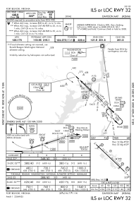
Runways:
| RWY identifier | QFU | Length (ft) | Width (ft) | Surface | LDA (ft) |
| 14 | 133° | 5421 | 75 | ASPH | |
| 32 | 313° | 5421 | 75 | ASPH | |
| H1 | 0° | 0 | 0 | UNK |
Airport contact information
Address: Fort Belvoir United States