


KCRW - West Virginia Intl Yeager
Located in Charleston, United States
ICAO - CRW, IATA - CRW
Data provided by AirmateGeneral information
Coordinates: N38°22'34" W81°35'34"
Elevation is 947 feet MSL.
Magnetic variation is -06° East View others Airports in West Virginia
Operational data
Special qualification required
Current time UTC:
Current local time:
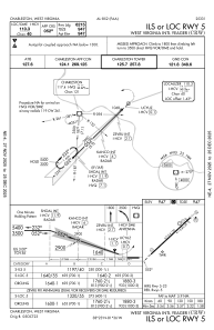
Communications frequencies: [VIEW]
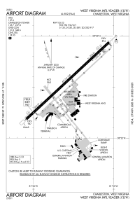
Runways:
| RWY identifier | QFU | Length (ft) | Width (ft) | Surface | LDA (ft) |
| 05 | 47° | 6715 | 150 | ASPH | 6215 |
| 23 | 227° | 6715 | 150 | ASPH | 6215 |
Airport contact information
Address: Charleston United States