


KCID - The Eastern Iowa
Located in Cedar Rapids, United States
ICAO - CID, IATA - CID
Data provided by AirmateGeneral information
Coordinates: N41°53'5" W91°42'39"
Elevation is 869 feet MSL.
Magnetic variation is 02° East View others Airports in Iowa
Operational data
Special qualification required
Current time UTC:
Current local time:
Communications frequencies: [VIEW]
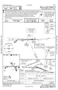
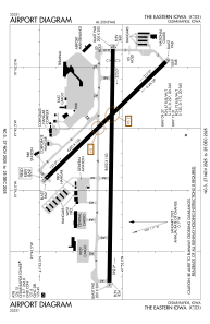
Runways:
| RWY identifier | QFU | Length (ft) | Width (ft) | Surface | LDA (ft) |
| 09 | 91° | 8600 | 150 | CONC | 8175 |
| 27 | 271° | 8600 | 150 | CONC | 8175 |
| 13 | 136° | 6200 | 150 | CONC | 6200 |
| 31 | 316° | 6200 | 150 | CONC | 6200 |
Airport contact information
Address: Cedar Rapids United States
