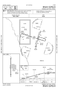
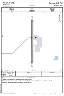


KCEA - Cessna Acft Fld
Located in Wichita, United States
ICAO - CEA, IATA - CEA
Data provided by AirmateGeneral information
Coordinates: N37°38'55" W97°15'2"
Elevation is 1378 feet MSL.
Magnetic variation is 08° East View others Airports in Kansas
Operational data
Special qualification required
Current time UTC:
Current local time:
Communications frequencies: [VIEW]
Runways:
| RWY identifier | QFU | Length (ft) | Width (ft) | Surface | LDA (ft) |
| 17 | 180° | 3873 | 40 | ASPH | |
| 35 | 0° | 3873 | 40 | ASPH |
Airport contact information
Address: Wichita United States