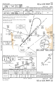
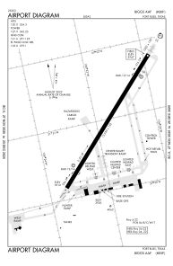


KBIF - Biggs Aaf (Fort Bliss)
Located in Fort Bliss/El Paso/, United States
ICAO - BIF, IATA - BIF
Data provided by AirmateGeneral information
Coordinates: N31°50'58" W106°22'48"
Elevation is 3946 feet MSL.
Magnetic variation is 08° East View others Airports in Texas
Operational data
Special qualification required
Current time UTC:
Current local time:
Communications frequencies: [VIEW]
Runways:
| RWY identifier | QFU | Length (ft) | Width (ft) | Surface | LDA (ft) |
| 04 | 44° | 13554 | 150 | CONC | |
| 22 | 224° | 13554 | 150 | CONC |
Airport contact information
Address: Fort Bliss/El Paso/ United States