


KAMA - Rick Husband Amarillo Intl
Located in Amarillo, United States
ICAO - AMA, IATA - AMA
Data provided by AirmateGeneral information
Coordinates: N35°13'10" W101°42'21"
Elevation is 3606 feet MSL.
Magnetic variation is 08° East View others Airports in Texas
Operational data
Special qualification required
Current time UTC:
Current local time:
Communications frequencies: [VIEW]
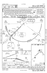
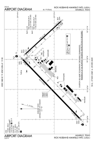
Runways:
| RWY identifier | QFU | Length (ft) | Width (ft) | Surface | LDA (ft) |
| 04 | 46° | 13502 | 200 | CONC | 13502 |
| 22 | 226° | 13502 | 200 | CONC | 13502 |
| 13 | 137° | 7901 | 150 | CONC | 7901 |
| 31 | 317° | 7901 | 150 | CONC | 7901 |
Airport contact information
Address: Amarillo United States
