


K75 - Osborne Muni
Located in Osborne, United States
ICAO - K75, IATA -
Data provided by AirmateGeneral information
Coordinates: N39°25'60" W98°40'48"
Elevation is 1547 feet MSL.
Magnetic variation is 08° East View others Airports in Kansas
Operational data
Special qualification required
Current time UTC:
Current local time:
Weather at : KRSL - Russell Muni ( 63 km )
METAR: KRSL 152200Z AUTO 18025G36KT 10SM SCT024 33/14 A2973 RMK AO2 PK WND 20036/2154 T03280144
TAF: KRSL 151729Z 1518/1618 19020G30KT P6SM SCT100 FM160100 17016G24KT P6SM SCT250 FM161400 20018G26KT P6SM FEW240
Communications frequencies: [VIEW]
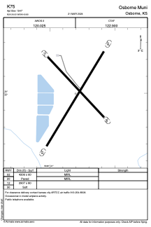
Runways:
| RWY identifier | QFU | Length (ft) | Width (ft) | Surface | LDA (ft) |
| 02 | 0° | 4206 | 60 | ASPH | |
| 20 | 0° | 4206 | 60 | ASPH | |
| 12 | 0° | 2907 | 80 | GRASS | |
| 30 | 0° | 2907 | 80 | GRASS |
Airport contact information
Address: Osborne United States