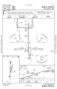
logo
Search for airport 
image banner adimage banner adimage banner ad
image banner ad

K50 - Cook Airfield

Located in Rose Hill, United States

ICAO - K50, IATA -

Data provided by Airmate  

General information

Coordinates: N37°33'55" W97°10'29"
Elevation is 1343 feet MSL.
Magnetic variation is 03° East
View others Airports in Kansas

Operational data

Special qualification required
Current time UTC:
Current local time:
Weather at : KIAB - Mc Connell Afb ( 10 km )
METAR: KIAB 030655Z AUTO 18013KT 10SM FEW100 21/18 A2975 RMK AO2 LTG DSNT N SLP065 T02060178
TAF: TAF KIAB 030200Z 0302/0408 15009KT 9999 SCT150 QNH2976INS BECMG 0310/0311 16012G22KT 8000 -SHRA SCT007 BKN015 QNH2979INS TEMPO 0313/0316 VRB25G35KT 6000 -TSRA BKN007 OVC015CB BECMG 0317/0318 18015G25KT 9999 NSW BKN040 OVC080 QNH2956INS BECMG 0323/0324 17012G18KT 9999 BKN040 BKN055 510022 QNH2970INS BECMG 0402/0403 17009KT 9999 BKN025 OVC040 QNH2971INS TX29/0321Z TN21/0312Z
View NOTAMs / SUP AIP / TFR affecting this airport [VIEW]
Communications frequencies: [VIEW]

Runways:

RWY identifierQFULength (ft)Width (ft)SurfaceLDA (ft)
01160050GRASS
19160050GRASS
17347240ASPH
35347240ASPH

Airport contact information

Address: Rose Hill United States

Other aviation service providers

Flight schools

Compass Rose Aviation

Compass Rose Aviation

Satellite view of K50