


ID67 - Sands
Located in Horseshoe Bend, United States
ICAO - ID67, IATA -
Data provided by AirmateGeneral information
Coordinates: N43°51'38" W116°15'46"
Elevation is 4310 feet MSL.
View others Airports in Idaho
Operational data
Special qualification required
Current time UTC:
Current local time:
Weather at : KBOI - Boise Air Trml/Gowen Fld ( 33 km )
METAR: KBOI 282355Z 20022G38KT 2 1/2SM +TSRA FEW039 FEW065 BKN100 19/12 A2989 RMK AO2 PK WND 21032/2354 WSHFT 2340 LTG DSNT SE-SW PRESRR P0000 T01940117
TAF: KBOI 282330Z 2900/2924 13015G25KT P6SM VCTS FEW050CB BKN100 TEMPO 2900/2903 VRB25G40KT 2SM -TSRA BKN050CB FM290300 31018G27KT P6SM SCT070 TEMPO 2903/2905 VRB20G35KT 6SM -TSRA BKN050CB
Communications frequencies: [VIEW]
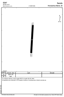
Runways:
| RWY identifier | QFU | Length (ft) | Width (ft) | Surface | LDA (ft) |
| 18 | 0° | 1024 | 40 | OTHER | |
| 36 | 0° | 1024 | 40 | OTHER |
Airport contact information
Address: Horseshoe Bend United States