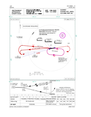


HKEL - Eldoret Intl
Located in Eldoret, Kenya
ICAO - HKEL, IATA - EDL
Data provided by AirmateGeneral information
Coordinates: N0°24'14" E35°14'12"
Elevation is 6945 feet MSL.
Magnetic variation is 1° East View others Airports in Rift Valley Province
Operational data
Special qualification required
Current time UTC:
Current local time:
Weather
METAR: HKEL 152200Z 00000KT CAVOK 15/13 Q1024
TAF: TAF HKEL 151700Z 1518/1624 15010KT 9999 FEW020CB BKN080 BECMG 1521/1524 VRB03KT SCT016 BECMG 1608/1611 12010KT FEW023CB BKN024 BECMG 1620/1623 VRB03KT CAVOK
Communications frequencies: [VIEW]
Runways:
| RWY identifier | QFU | Length (ft) | Width (ft) | Surface | LDA (ft) |
| 08 | 79° | 11434 | 148 | ASPH | 11483 |
| 26 | 259° | 11434 | 148 | ASPH | 11483 |
Airport contact information
Address: Eldoret Kenya