


ENOL - Oerland
Located in Oerland, Norway
ICAO - ENOL, IATA - OLA
Data provided by AirmateGeneral information
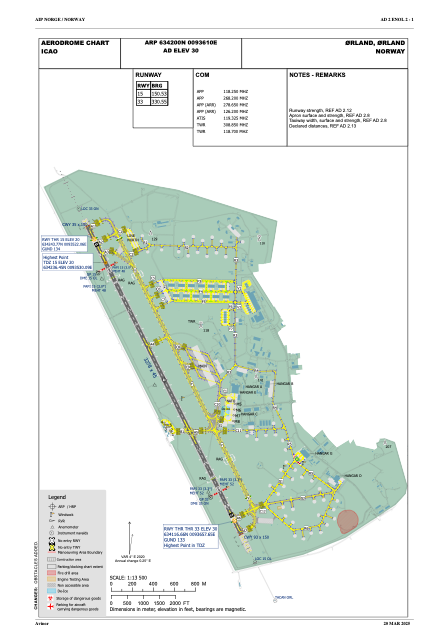
Coordinates: N63°42'0" E9°36'10"
Elevation is 30 feet MSL.
Magnetic variation is 3.5° East View others Airports in Sør-Trøndelag
Operational data
Special qualification required
Current time UTC:
Current local time:
Weather
METAR: ENOL 162020Z 36003KT 9999 -SHRA SCT035CB 15/10 Q1007 TEMPO SHRA
TAF: TAF ENOL 161700Z 1618/1718 32008KT 9999 SCT030 TEMPO 1618/1624 SHRA SCT030CB PROB30 TEMPO 1618/1620 TS BECMG 1704/1707 14012KT TEMPO 1711/1718 SHRA SCT030CB
Communications frequencies: [VIEW]
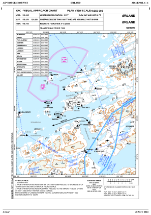
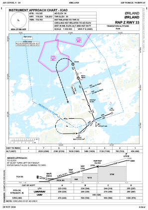
Runways:
| RWY identifier | QFU | Length (ft) | Width (ft) | Surface | LDA (ft) |
| 15 | 154° | 9022 | 108 | ASP | |
| 33 | 334° | 9022 | 108 | ASP |
Airport contact information
Address: Oerland Norway
