logo
Search for airport 
image banner adimage banner adimage banner ad
image banner ad

D69 - Rogersburg

Located in Anatone, United States

ICAO - D69, IATA -

Data provided by Airmate  

General information

Coordinates: N46°4'27" W116°57'54"
Elevation is 869 feet MSL.
 
View others Airports in Washington

Operational data

Special qualification required
Current time UTC:
Current local time:
Weather at : KLWS - Lewiston/Nez Perce County ( 34 km )
METAR: KLWS 031156Z AUTO 08003KT 8SM -RA SCT006 BKN040 OVC070 14/13 A2954 RMK AO2 SLP998 P0022 60026 70032 T01440133 10156 20144 56020
TAF: KLWS 031154Z 0312/0412 VRB05KT 4SM RA BR SCT020 OVC050 TEMPO 0312/0314 25007KT 2SM +RA BR SCT009 BKN015 OVC022 FM031600 28015G25KT P6SM BKN040 FM031900 30025G35KT P6SM FEW080 FM040300 28016G24KT P6SM SCT150 FM040600 28009KT P6SM BKN120 FM041100 15006KT P6SM BKN070 OVC100
View NOTAMs / SUP AIP / TFR affecting this airport [VIEW]
Communications frequencies: [VIEW]
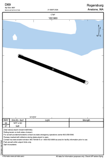
Runways:

RWY identifierQFULength (ft)Width (ft)SurfaceLDA (ft)
09112°147150GRASS
27292°147150GRASS

Airport contact information

Address: Anatone United States

Satellite view of D69