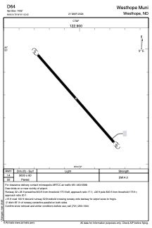


D64 - Westhope Muni
Located in Westhope, United States
ICAO - D64, IATA -
Data provided by AirmateGeneral information
Coordinates: N48°54'47" W101°2'1"
Elevation is 1492 feet MSL.
Magnetic variation is 10° East View others Airports in North Dakota
Operational data
Special qualification required
Current time UTC:
Current local time:
Weather at : KMIB - Minot Afb ( 60 km )
METAR: KMIB 051844Z 32031G42KT 4SM HZ FEW070 FEW200 20/04 A2949 RMK AO2A TWR VIS 4800 SLP987
TAF: TAF AMD KMIB 051830Z 0518/0623 29035G45KT 9999 BKN060 520003 QNH2947INS TEMPO 0518/0524 30040G50KT 530004 BECMG 0600/0601 30025G35KT 9999 FEW030 SCT065 520003 QNH2964INS BECMG 0604/0605 30015G25KT 9999 BKN060 WS020/32045KT QNH2970INS BECMG 0611/0612 30020G30KT 9999 SKC 510002 QNH2977INS BECMG 0618/0619 30025G35KT 9999 SKC 510003 QNH2978INS TX24/0521Z TN13/0609Z
Communications frequencies: [VIEW]
Runways:
| RWY identifier | QFU | Length (ft) | Width (ft) | Surface | LDA (ft) |
| 14 | 0° | 3000 | 60 | ASPH | |
| 32 | 0° | 3000 | 60 | ASPH |
Airport contact information
Address: Westhope United States