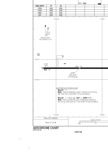


CZHP - High Prairie
Located in , Canada
ICAO - CZHP, IATA - ZHP
Data provided by AirmateGeneral information
Coordinates: N55°23'37" W116°28'30"
Elevation is 1975 feet MSL.
Magnetic variation is 16.45° East View others Airports in Alberta
Operational data
Special qualification required
Current time UTC:
Current local time:
Weather at : - ( 0 km )
METAR: CYHE 162242Z AUTO 28004KT 250V350 9SM FEW043 12/09 A3002 RMK SLP169
Communications frequencies: [VIEW]
Runways:
| RWY identifier | QFU | Length (ft) | Width (ft) | Surface | LDA (ft) |
| 07 | 90° | 4332 | 75 | ASPH | 4332 |
| 25 | 270° | 4332 | 75 | ASPH | 4332 |
Airport contact information
Address: Canada