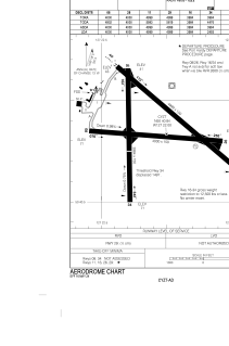


CYZT - Port Hardy
Located in Port Hardy, Canada
ICAO - CYZT, IATA - YZT
Data provided by AirmateGeneral information
Coordinates: N50°40'50" W127°21'60"
Elevation is 71 feet MSL.
Magnetic variation is 17.7856° East View others Airports in British Columbia
Operational data
Special qualification required
Current time UTC:
Current local time:
Communications frequencies: [VIEW]
Runways:
| RWY identifier | QFU | Length (ft) | Width (ft) | Surface | LDA (ft) |
| 11 | 130° | 4999 | 150 | ASPH | 4999 |
| 29 | 310° | 4999 | 150 | ASPH | 4999 |
| 08 | 94° | 4000 | 150 | ASPH | 4000 |
| 26 | 274° | 4000 | 150 | ASPH | 4000 |
| 16 | 180° | 3984 | 150 | ASPH | 3984 |
| 34 | 360° | 3984 | 150 | ASPH | 2493 |
Airport contact information
Address: Port Hardy Canada