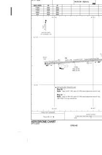


CYRS - Red Sucker Lake
Located in , Canada
ICAO - CYRS, IATA - YRS
Data provided by AirmateGeneral information
Coordinates: N54°10'3" W93°33'27"
Elevation is 745 feet MSL.
Magnetic variation is -1.05° East View others Airports in Manitoba
Operational data
Special qualification required
Current time UTC:
Current local time:
Communications frequencies: [VIEW]
Runways:
| RWY identifier | QFU | Length (ft) | Width (ft) | Surface | LDA (ft) |
| 09 | 86° | 3552 | 98 | GRAVE | 3555 |
| 27 | 266° | 3552 | 98 | GRAVE | 3555 |
Airport contact information
Address: Canada