


B10 - Bowman Fld
Located in Livermore Falls, United States
ICAO - B10, IATA -
Data provided by AirmateGeneral information
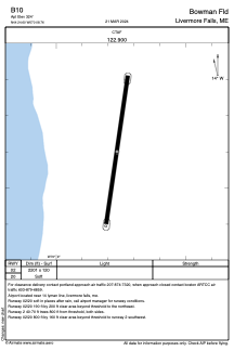
Coordinates: N44°24'36" W70°8'46"
Elevation is 324 feet MSL.
Magnetic variation is -18° East View others Airports in Maine
Operational data
Special qualification required
Current time UTC:
Current local time:
Communications frequencies: [VIEW]
Runways:
| RWY identifier | QFU | Length (ft) | Width (ft) | Surface | LDA (ft) |
| 02 | 8° | 2201 | 120 | GRASS | |
| 20 | 188° | 2201 | 120 | GRASS |
Airport contact information
Address: Livermore Falls United States